







How Israel Turned Gaza Into an “Annihilation Zone”
Eyal Weizman on the Ways Land Can Tell the Story of Genocide
The Caterpillars have been here for a long time. In August 1950 the area that came to be known as the Gaza Strip was cut off from the rest of Palestine by a ditch carved into the soil by a single-blade plough pulled by a tractor. An archival photograph depicting the scene shows the tractor to be a Second World War-era Caterpillar, model D6. It was part of a convoy of military vehicles. Behind it drove Israeli and Egyptian troops and United Nations truce observers.
An Israeli soldier named Amnon Degieli described the scene. “A jeep with the two sector commanders, the Israeli and the Egyptian, led a convoy of vehicles. The officers held a map at a scale of 1:100,000 on which the border was sketched with a thick pencil line. On the ground the width of the pencil line was one hundred metres.” Entire homesteads and farms fell within it. Mordechai Galili, another soldier who, like Degieli, was a settler from a nearby kibbutz named Nirim, described the process for the settlement’s bulletin. He said Israeli and Egyptian troops “argued over every millimetre…the bargaining was like in a fish market. There were arguments over every tree.” In the scorching August heat, the “American major”—presumably one of the Colombian UN officers posted to the frontier—”took off his shirt to sunbathe.” The photograph shows several of the troops lounging in what looks like an abandoned field, while the labor of partitioning Palestine was performed. The “American” had the last word. “A signal was given, and the tractor ploughs a straight line right through orchards, vineyards and wadis.” The ploughing continued segment after segment. In one location, Galili writes, “the tractor climbs over a cactus fence and parts it with pleasure.”
Elsewhere alarmed Palestinian farmers—witnessing the growing trench tearing them away from their lands—surround the vehicles. The Israelis taunt them: “Take a photograph of this place because you will not see it again.” A Palestinian man shouts that they will soon have their land back and tells the settlers to return where they came from. A desperate farmer pleads with the Egyptian officers to move the line beyond his field. The Egyptians impatiently brush him away. Along another segment, “an orchard of plum and apricot trees ended up on our side. The owners are on the other side of the line. In front of their eyes we fill our stomachs and pockets, and throw the fruit stone at them, ‘Eat some!'” The ploughing progressed from north to south. The landscape was rich with fields and orchards.
At yet another location, Palestinian farmers realized that the plough was about to cut between two contiguous villages. “The people in the villages of Abasan and Khiza‘a came out in force, screaming, shouting, and yelling.” Women and children gathered around the convoy. The demarcation process was stopped, and the Egyptian army led the convoy away. On this occasion, the Palestinian farmers succeeded in shifting the line.
This rare moment of success was recorded years later by Salman Abu Sitta, who on 14 May 1948—the day the state of Israel was declared, when he was ten years old—had been expelled with his family from their agricultural village of Ma‘in Abu Sitta (al-Ma‘in) located on a sandstone hill, some three kilometers on the Israeli-controlled side of the plough line and overlooking the towns of Khan Younis, the coast-line, and beyond the horizon the Egyptian Sinai Desert. Abu Sitta has become one of the most prolific chroniclers of the ongoing Palestinian Nakba and one of the most forceful advocates for Palestinian return. In February 2025 Salman came to the offices of Forensic Architecture, the London-based research agency I run. Together we worked on a careful digital reconstruction of al-Ma‘in—a village whose architecture, agriculture and history are central to this project.
Ploughing was an act of double erasure, both of what existed and of the traces that any erasure had at all taken place.
The plough line was not an internationally recognized border but it gave rise to two new and complementary territorial units: the Gaza Strip and the Gaza Envelope. The former was a concentration area for 200,000 refugees expelled from 247 localities, villages and towns and the area’s original 80,000 inhabitants; and the latter a frontier zone designed to incarcerate them. The difference between the two sides of the plough line was stark, writes Galili. “The Egyptian side is dark with Arabs and their herds while the Israeli side is empty.” The administrative region of the “Envelope” was officially declared only in the early 2000s, as a means of providing the area with Israeli state subsidies, but the term is an apt description of this frontier zone of civilian and military installations that started to be assembled at the same time as the Gaza Strip was formed and designed to enclose it and put it under permanent siege.
Nirim, the kibbutz settlement from which the Israeli soldiers who ploughed the border line arrived, was built on the ruins of al-Ma‘in. They fortified behind an enclosure of fences and trenches shaped like a pentagon—a five-centuries-old typology of military fortifications. The settlers dismantled the ruins, and over the years erased most of the remaining traces of al-Ma‘in—save for one concrete building and a deep well which they used. The means of erasure was cultivation. The settlers ploughed over all surface elements—buildings, the stone walls between the plots of wheat and barley, the vegetable gardens, the pedestrian routes, the vehicle roads, the agricultural storage facilities, the two buildings that provided the first regional school in the area, and several burial grounds.
Ploughing was an act of double erasure, both of what existed and of the traces that any erasure had at all taken place. Soon the fields covered the remnants of al-Ma‘in with a dense plume of fresh vegetation. This erasure was meant to transform the land beyond recognition and leave the Palestinian villagers pushed into the coastal area with nothing to return to. The task of Nirim, like other settlements and military bases entrenched around the newly formed Gaza Strip, was to guard the frontier against Palestinian refugees, like members of the Abu Sitta family, who were trying to return to their lands to salvage possessions, harvest crops or fight the occupiers. The settlers were ordered to shoot-to-kill at anyone—armed or unarmed, man or woman—who crossed the plough line. Nirim, along with the kibbutz settlements of Nir Oz, Magen and Ein HaShlosha, also built on Abu Sitta’s land, would be amongst the hardest hit on October 7, 2023.
*
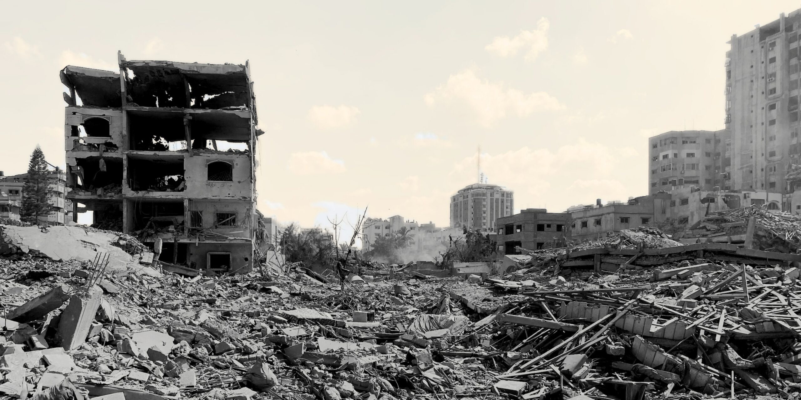
“The Occupation [Army] has changed the Strip’s topography beyond recognition,” wrote Palestinian poet Omar Moussa at the end of November 2023. By that time thousands of ground-penetrating bombs had ripped through the subsoil with the seismic force of small earthquakes. They created craters deep enough to swallow entire buildings. Giant armored bulldozers—now Caterpillar model D9—stabbed their front blades into the ground and drove forward, flipping fields and shaving off orchards. A Palestinian farmer sent Forensic Architecture a voice memo describing the family farm, which had a vegetable garden and one of the last olive, pomegranate and citrus orchards in the area: “It is now the same as it was before, desert. I wouldn’t be able to recognize it.”
After the farms came the outer neighborhoods of villages, cities and refugee camps. Videos posted by soldiers showed bulldozers felling line after line of homes, tearing through the asphalt of roads and letting raw sewage bleed out of the broken pipes onto the exposed soil. The bulldozers proceeded to turn Gaza’s Coca-Cola factory into a landscape of glittering glass. They stopped at nothing, scraping through archaeological sites and cemeteries. “Our job is to flatten Gaza,” one of the units operating the bulldozers posted on social media. “Palestinians will have nowhere to return to,” said another Israeli officer, “all they will find is scorched earth. No houses, no agriculture, no nothing.” Further west towards the coast another soldier marveled at the vista they opened, “a momentary view, pure and profound, of clean nature.” “If we survive this war,” Omar Moussa quoted a friend asking, “what would be our meeting point?”
Ungrounding is unlike other kinds of destruction in which the surface markings of inhabited areas—plot lines, roads, fields, gardens, walking paths—remain identifiable. In all other wartime destruction that I have studied, even when buildings collapse, one can still tell where they once stood, and understand something of the social reality that the urban surface held together. After a conflict ends, buildings and neighborhoods can be extruded from their footprints. Ungrounding, on the other hand, aims to remove a society from its place and erase all traces to its previous existence. It extends from buildings down to the soil beneath them. It is a type of violence that is earth-shaping, terra-forming. Ungrounding is not a by-product of military confrontation but rather its aim. It destroys all conditions that sustain life and produces an empty slate, a tabula rasa. The monochrome desert of upturned soil is the material signature of Israel’s genocide.
Ungrounding is not a by-product of military confrontation but rather its aim. It destroys all conditions that sustain life and produces an empty slate, a tabula rasa.
Soil is a composition of multiple elements. Grains of sand have each a different origin—seashells, coral, rocks and minerals—likewise the ungrounded soil of Gaza after October 2023 became a mixture of fragments of all elements that had previously composed urban life—crushed concrete, plaster, plastic, glass, dead plants, sand. Since October 2023, Gaza was not only turned into a demolition zone but also into a construction site. The bulldozers carved a new militarized master plan through the pulverized rubble, like a finger sketch on a dusty windscreen. In this design, rubble mounds became the basic architectural unit, the walls with which every type of structure was made. Bulldozers shuffled right through the rubble to make roads that cut Gaza into separate sections.
Along these routes, the bulldozers piled up mounds to enclose fortified compounds, military outposts and detention facilities where Palestinians were interrogated and tortured. The relatively flat topography of the Gaza Strip was gradually transformed into a stormy landscape of artificial dunes that drifted along with the movement of the army. The army turned the surface of the earth into a gelatinous and fluid medium. Earthwaves rose, receded and settled when the army’s priorities changed. The earth storm swallowed people inside. There are estimated to be 11,000 Palestinians missing, many of them in deep craters or under tall mounds of rubble, drowned in earth without a proper burial. Even the markers placed over these grave sites have been swept away in the earth storm. Often, at Forensic Architecture, we seek to identify the location of videos by visible urban markers, but as the genocide proceeded, available markers disappeared and the setting of the videos was nothing but the indistinct and shifting landscape of rubble dunes, making many difficult to locate.
Much of the ungrounding occurs in areas that the army refers to as a “buffer zone” all along Gaza’s fences. Throughout the past two years the buffer zone expanded until it covered almost all of the territory of the Strip. This ungrounded area is forbidden for Palestinians to return to. The army regarded it as shetah hashmada—an “annihilation zone” where every Palestinian present could be shot on sight. In the buffer zone no plant or structure remained. This aims to remove any hiding place and expose Palestinians to fire from military snipers or from armed quadcopter drones that patrol the dune landscape. The ever-growing tide of destruction pushed Palestinians into dense and crowded pockets of land on the coastal sand dunes. The army called these areas “humanitarian zones,” though they are anything but humanitarian, and are better described as “concentration areas” or concentration camps. Tents were erected on the dunes and on the seashore.
When displaced Palestinians ran out of sand, tents were erected among the ruins, on piers extending into the sea, on roads and near garbage dumps. Scattered on the dunes, the surviving population of Gaza was reduced to bare existence, subject to unrelenting hunger and thirst under the ever-present hum of killer drones and bomber jets. Israel wanted Palestinians trapped in these islands either to leave or die, and the exit points were closed. The October 2025 ceasefire did not bring an end to Israeli attacks but it froze the situation on the ground, leaving Israel in control of an ungrounded buffer zone extending over 58 per cent of the Strip with Palestinians crowded within the broken cities and tent camps along the coast.
____________________________
From Ungrounding: The Architecture of Genocide by Eyal Weizman, published by Penguin Press, an imprint of Penguin Publishing Group, a division of Penguin Random House, LLC. Copyright © 2026 by Eyal Weizman. Featured image courtesy Palestinian News & Information Agency (Wafa) in contract with APAimages (via)

Eyal Weizman
Eyal Weizman is the founder and director of Forensic Architecture and Professor of Spatial and Visual Cultures at Goldsmiths, University of London, where, in 2005, he founded the Centre for Research Architecture. In 2007, with Sandi Hilal and Alessandro Petti, he established the architectural collective DAAR in Beit Sahour, Palestine. He is the author of numerous books, including Hollow Land, The Least of all Possible Evils, Investigative Aesthetics, The Conflict Shoreline, and Forensic Architecture. He is the recipient of the Right Livelihood Award known as the “Alternative Nobel Prize,” a Peabody Award, the European Cultural Foundation Award, and numerous other awards in human rights, investigative journalism, art, and architecture. In 2019, he was elected Life Fellow of the British Academy.