


Pearl Harbor Was Not the Worst Thing to Happen to the U.S. on December 7, 1941
Daniel Immerwahr on the Erasure of American "Territories" from US History
December 7, 1941. Japanese planes appear over a naval base on O‘ahu. They drop aerial torpedoes, which dive underwater, wending their way toward their targets. Four strike the USS Arizona, and the massive battleship heaves in the water. Steel, timber, diesel oil, and body parts fly through the air. The flaming Arizona tilts into the ocean, its crew diving into the oil-covered waters. For a country at peace, this is a violent awakening. It is, for the United States, the start of the Second World War.
There aren’t many historical episodes more firmly lodged in national memory than this one, the attack on Pearl Harbor. It’s one of the few events that most people can put a date to (December 7, the “date which will live in infamy,” as Franklin Delano Roosevelt put it). Hundreds of books have been written about it—the Library of Congress holds more than 350. And Hollywood has made movies, from the critically acclaimed From Here to Eternity (1953) starring Burt Lancaster to the critically derided Pearl Harbor (2001) starring Ben Affleck.
But what those films don’t show is what happened next. Nine hours after Japan attacked the territory of Hawai‘i, another set of Japanese planes came into view over another US territory, the Philippines. As at Pearl Harbor, they dropped their bombs, hitting several air bases, to devastating effect.
The army’s official history of the war judges the Philippine bombing to have been just as disastrous as the Hawaiian one. At Pearl Harbor, the Japanese hobbled the United States’ Pacific fleet, sinking four battleships and damaging four others. In the Philippines, the attackers laid waste to the largest concentration of US warplanes outside North America—the foundation of the Allies’ Pacific air defense.
The United States lost more than planes. The attack on Pearl Harbor was just that, an attack. Japan’s bombers struck, retreated, and never returned. Not so in the Philippines. There, the initial air raids were followed by more raids, then by invasion and conquest. Sixteen million Filipinos—US nationals who saluted the Stars and Stripes and looked to FDR as their commander in chief—fell under a foreign power. They had a very different war than the inhabitants of Hawai‘i did.
Nor did it stop there. The event familiarly known as “Pearl Harbor” was in fact an all-out lightning strike on US and British holdings throughout the Pacific. On a single day, the Japanese attacked the US territories of Hawai‘i, the Philippines, Guam, Midway Island, and Wake Island. They also attacked the British colonies of Malaya, Singapore, and Hong Kong, and they invaded Thailand.
It was a phenomenal success. Japan never conquered Hawai‘i, but within months Guam, the Philippines, Wake, Malaya, Singapore, and Hong Kong all fell under its flag. Japan even seized the westernmost tip of Alaska, which it held for more than a year.
Looking at the big picture, you start to wonder if “Pearl Harbor”—the name of one of the few targets Japan didn’t invade—is really the best shorthand for the events of that fateful day.
But though those embassies were outposts of the United States, there was little public sense that the country itself had been harmed.
*
“Pearl Harbor” wasn’t how people referred to the bombings, at least not at first. How to describe them, in fact, was far from clear. Should the focus be on Hawai‘i, the closest target to North America and the first bit of US soil Japan had struck? Or should it be the Philippines, the far larger and more vulnerable territory? Or Guam, the one that surrendered nearly immediately? Or all the Pacific holdings, including the uninhabited Wake and Midway, together?
“The facts of yesterday and today speak for themselves,” Roosevelt said in his address to Congress—his “Infamy” speech. But did they? Japs Bomb Manila, Hawaii was the headline of a New Mexico paper; Japanese Planes Bomb Honolulu, Island of Guam was that of one in South Carolina. Sumner Welles, FDR’s undersecretary of state, described the event as “an attack upon Hawaii and upon the Philippines.” Eleanor Roosevelt used a similar formulation in her radio address on the night of December 7, when she spoke of Japan “bombing our citizens in Hawaii and the Philippines.”
That was how the first draft of FDR’s speech went, too. It presented the event as a “bombing in Hawaii and the Philippines.” Yet Roosevelt toyed with that draft all day, adding things in pencil, crossing other bits out. At some point he deleted the prominent references to the Philippines and settled on a different description. The attack was, in his revised version, a “bombing in Oahu” or, later in the speech, “on the Hawaiian Islands.” He still mentioned the Philippines, but only as an item on a terse list of Japan’s other targets: Malaya, Hong Kong, Guam, the Philippines, Wake Island, and Midway—presented in that order. That list mingled U.S. and British territories together, giving no hint as to which was which.
Why did Roosevelt demote the Philippines? We don’t know, but it’s not hard to guess. Roosevelt was trying to tell a clear story: Japan had attacked the United States. But he faced a problem. Were Japan’s targets considered “the United States”? Legally, yes, they were indisputably U.S. territory. But would the public see them that way? What if Roosevelt’s audience didn’t care that Japan had attacked the Philippines or Guam? Polls taken slightly before the attack show that few in the continental United States supported a military defense of those remote territories.
Consider how similar events played out more recently. On August 7, 1998, al-Qaeda launched simultaneous attacks on U.S. embassies in Nairobi, Kenya, and Dar es Salaam, Tanzania. Hundreds died (mostly Africans), and thousands were wounded. But though those embassies were outposts of the United States, there was little public sense that the country itself had been harmed. It would take another set of simultaneous attacks three years later, on New York City and Washington, D.C., to provoke an all-out war.
An embassy is different from a territory, of course. Yet a similar logic held in 1941. Roosevelt no doubt noted that the Philippines and Guam, though technically part of the United States, seemed foreign to many. Hawai‘i, by contrast, was more plausibly “American.” Though it was a territory rather than a state, it was closer to North America and significantly whiter than the others. As a result, there was talk of eventual statehood (whereas the Philippines was provisionally on track for independence).
Yet even when it came to Hawai‘i, Roosevelt felt a need to massage the point. Though the territory had a substantial white population, nearly three-quarters of its inhabitants were Asians or Pacific Islanders. Roosevelt clearly worried that his audience might regard Hawai‘i as foreign. So on the morning of his speech, he made another edit. He changed it so that the Japanese squadrons had bombed not the “island of Oahu,” but the “American island of Oahu.” Damage there, Roosevelt continued, had been done to “American naval and military forces,” and “very many American lives” had been lost.
An American island, where American lives were lost—that was the point he was trying to make. If the Philippines was being rounded down to foreign, Hawai‘i was being rounded up to “American.”
“Yesterday, December 7, 1941—a date which will live in infamy—the United States of America was suddenly and deliberately attacked by naval and air forces of the Empire of Japan” is how Roosevelt’s speech began. Note that in this formulation Japan is an “empire,” but the United States is not. Note also the emphasis on the date. It was only at Hawai‘i and Midway, of all Japan’s targets, that the vagaries of the international date line put the event on December 7. Everywhere else, it occurred on December 8, the date the Japanese use to refer to the attack.
Did Roosevelt underscore the date in a calculated attempt to make it all about Hawai‘i? Almost certainly not. Still, his “date which will live in infamy” phrasing further encouraged a narrow understanding of the event, one that left little room for places like the Philippines.
For Filipinos, this could be exasperating. A reporter described the scene in Manila as the crowds listened to Roosevelt’s speech over the radio. The president spoke of Hawai‘i and the many lives lost there. Yet he only mentioned the Philippines, the reporter noted, “very much in passing.” Roosevelt made the war “seem to be something close to Washington and far from Manila.”
This was not how it looked from the Philippines, where air-raid sirens continued to wail. “To Manilans the war was here, now, happening to us,” the reporter wrote. “And we have no air-raid shelters.”
If the Philippines was being rounded down to foreign, Hawai‘i was being rounded up to “American.”
*
Hawai‘i, the Philippines, Guam—it wasn’t easy to know how to think about such places or even what to call them. At the turn of the twentieth century, when many were acquired (Puerto Rico, the Philippines, Guam, American Samoa, Hawai‘i, Wake), their status was clear. They were, as Theodore Roosevelt and Woodrow Wilson unabashedly called them, colonies.
Yet that spirit of forthright imperialism didn’t last. Within a decade or two, after passions had cooled, the c-word became taboo. “The word colony must not be used to express the relationship which exists between our government and its dependent peoples,” an official admonished in 1914. Better to stick with a gentler term, used for them all: territories.
It was gentler because the United States had had territories before, such as Arkansas and Montana. Their place in the national firmament was a happy one. The western territories were the frontier, the leading edge of the country’s growth. They might not have had all the rights that states did, but once they were “settled” (i.e., populated by whites), they were welcomed fully into the fold as states.
But if places like the Philippines and Puerto Rico were territories, they were territories of a different sort. Unlike the western territories, they weren’t obviously slated for statehood. Nor were they widely understood to be integral parts of the nation.
A striking feature, in fact, of the overseas territories was how rarely they were even discussed. The maps of the country that most people had in their heads didn’t include places like the Philippines. Those mental maps imagined the United States to be contiguous: a union of states bounded by the Atlantic, the Pacific, Mexico, and Canada.
That is how most people envision the United States today, possibly with the addition of Alaska and Hawai‘i. The political scientist Benedict Anderson called it the “logo map.” Meaning that if the country had a logo, this shape would be it.
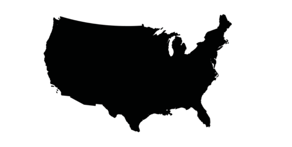
The problem with the logo map, however, is that it isn’t right. Its shape doesn’t match the country’s legal borders. Most obviously, the logo map excludes Hawai‘i and Alaska, which became states in 1959 and now appear on virtually all published maps of the country. But it’s also missing Puerto Rico, which, though not a state, has been part of the country since 1899. When have you ever seen a map of the United States that had Puerto Rico on it? Or American Samoa, Guam, the U.S. Virgin Islands, the Northern Marianas, or any of the other smaller islands the United States has annexed over the years?
In 1941, the year Japan attacked, a more accurate picture would have been this:
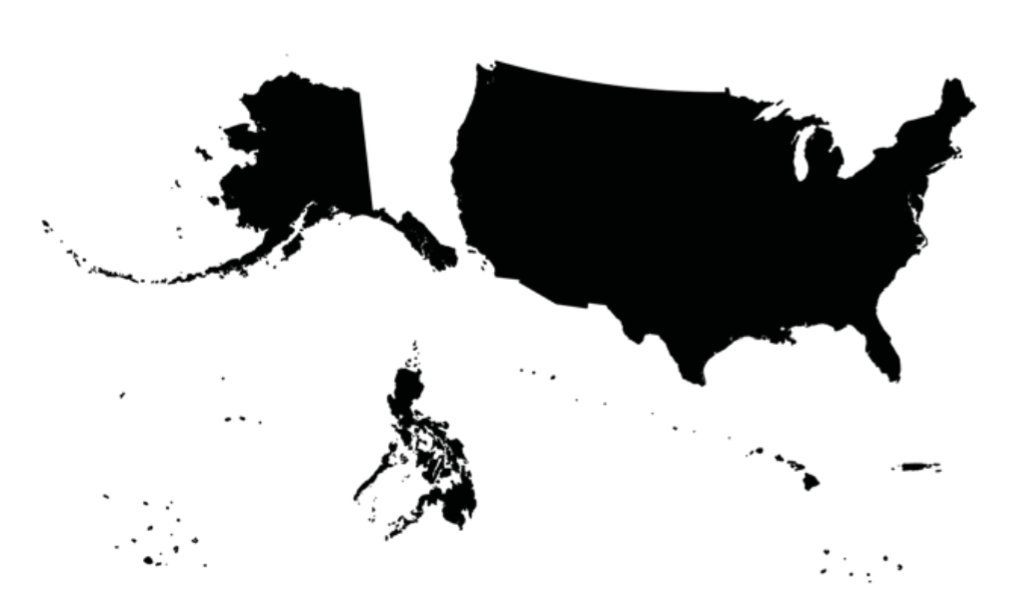
What this map shows is the country’s full territorial extent: the “Greater United States,” as some at the turn of the twentieth century called it. In this view, the place normally referred to as the United States—the logo map—forms only a part of the country. A large and privileged part, to be sure, yet still only a part. Residents of the territories often call it the “mainland.”
I’ve drawn this map to show the inhabited parts of the Greater United States at the same scale and with equal-area projections. So Alaska isn’t shrunken down to fit into a small inset, as it is on most maps. It’s the right size—i.e., it’s huge. The Philippines, too, looms large, and the Hawaiian island chain—the whole chain, not just the eight main islands shown on most maps—if superimposed on the mainland would stretch almost from Florida to California.
This map also shows territory at the other end of the size scale. In the century before 1940, the United States claimed nearly a hundred uninhabited islands in the Caribbean and the Pacific. Some claims were forgotten in time—Washington could be surprisingly lax about keeping tabs. The twenty-two islands I’ve included are the ones that appeared in official tallies (the census or other governmental reports) in the 1940s. I’ve represented them as clusters of dots in the bottom left and right corners, though they’re so small that were I to draw them to scale, they’d be invisible.
When it came to strategy, those dots mattered.
Why include them at all? Was it important that the United States possessed, to take one example, Howland Island, a bare plot of land in the middle of the Pacific, only slightly larger than Central Park? Yes, it was. Howland wasn’t large or populous, but in the age of aviation, it was useful. At considerable expense, the government hauled construction equipment out to Howland and built an airstrip there—it’s where Amelia Earhart was heading when her plane went down. The Japanese, fearing what the United States might do with such a well-positioned airstrip, bombed Howland the day after they struck Hawai‘i, Guam, Wake, Midway, and the Philippines.
When it came to strategy, those dots mattered.
The logo map excludes all that—large colonies and pinprick islands alike. And there is something else misleading about it. It suggests that the United States is a politically uniform space: a union, voluntarily entered into, of states standing on equal footing with one another. But that’s not true, and it’s never been true. From the day the treaty securing independence from Britain was ratified, right up to the present, it’s been a collection of states and territories. It’s been a partitioned country, divided into two sections, with different laws applying in each.
The United States of America has contained a union of American states, as its name suggests. But it has also contained another part: not a union, not states, and (for most of its history) not wholly in the Americas.
*
This is not a country that has kept its hands to itself.
The proposition that the United States is an empire is less controversial today. The leftist author Howard Zinn, in his immensely popular A People’s History of the United States, wrote of the “global American empire,” and his graphic-novel spin-off is called A People’s History of American Empire. On the far right, the politician Pat Buchanan has warned that the United States is “traveling the same path that was trod by the British Empire.” In the vast political distance between Zinn and Buchanan, there are millions who would readily agree that the United States is, in at least some sense, imperial.
The case can be made in a number of ways. The dispossession of Native Americans and relegation of many to reservations was pretty transparently imperialist. Then, in the 1840s, the United States fought a war with Mexico and seized a third of it. Fifty years later, it fought a war with Spain and claimed the bulk of Spain’s overseas territories.
Empire isn’t just landgrabs, though. What do you call the subordination of African Americans? In W.E.B. Du Bois’ eyes, black people in the United States looked more like colonized subjects than like citizens. Many other black thinkers, including Malcolm X and the leaders of the Black Panthers, have agreed.
Or what about the spread of U.S. economic power abroad? The United States might not have physically conquered Western Europe after World War II, but that didn’t stop the French from complaining of “coca-colonization.” Critics there felt swamped by U.S. commerce. Today, with the world’s business denominated in dollars and McDonald’s in more than a hundred countries, you can see they might have had a point.
Then there are the military interventions. The years since the Second World War have brought the U.S. military to country after country. The big wars are well-known: Korea, Vietnam, Iraq, Afghanistan. But there has also been a constant stream of smaller engagements. Since 1945, U.S. armed forces have been deployed abroad for conflicts or potential conflicts 211 times in 67 countries. Call it peacekeeping if you want, or call it imperialism. But clearly this is not a country that has kept its hands to itself.
Yet in all the talk of empire, one thing that often slips from view is actual territory. Yes, many would agree that the United States is or has been an empire, for all the reasons above. But how much can most people say about the colonies themselves? Not, I would wager, very much.
And why should they be able to? Textbooks and overviews of U.S. history invariably feature a chapter on the 1898 war with Spain that led to the acquisition of many of the territories and the Philippine War that followed it (“the worst chapter in almost any book,” one reviewer griped). Yet, after that, coverage trails off. Territorial empire is treated as an episode rather than a feature. The colonies, having been acquired, vanish.
It’s not as if the information isn’t out there. Scholars, many working from the sites of empire themselves, have assiduously researched this topic for decades. It’s just that when it comes time to zoom out and tell the story of the country as a whole, the territories tend to fall away. The confusion and shoulder-shrugging indifference that mainlanders displayed at the time of Pearl Harbor hasn’t changed much at all.
Ultimately, the problem isn’t a lack of knowledge. The libraries contain literally thousands of books about U.S. overseas territory. The problem is that those books have been sidelined—led, so to speak, on the wrong shelves. They’re there, but so long as we’ve got the logo map in our heads, they’ll seem irrelevant. They’ll seem like books about foreign countries.
__________________________________
From How to Hide an Empire: A History of the Greater United States. Used with permission of Farrar, Straus & Giroux. Copyright © 2019 by Daniel Immerwahr.
Daniel Immerwahr
Daniel Immerwahr is an associate professor of history at Northwestern University and the author of Thinking Small: The United States and the Lure of Community Development, which won the Organization of American Historians’ Merle Curti Award. He has written for Slate, n+1, Dissent, and other publications.