


Has the Time Finally Come for Multispecies Maps?
Ryan Huling on New Innovations in Cartography That Allow Us to Appreciate the Natural World
Imagine, if you will, a college student returning from summer break for the start of a new semester. Heading to her first class of the day, she pulls up the campus map on her phone and is intrigued to find two options: human or multispecies.
Instinctively, she clicks “human” and sees the familiar layout of the idyllic school grounds she’s come to know. It confirms that she’s headed in the right direction. She starts to put her phone away but hesitates. After pausing for a moment, she navigates back to her browser and clicks “multispecies.”
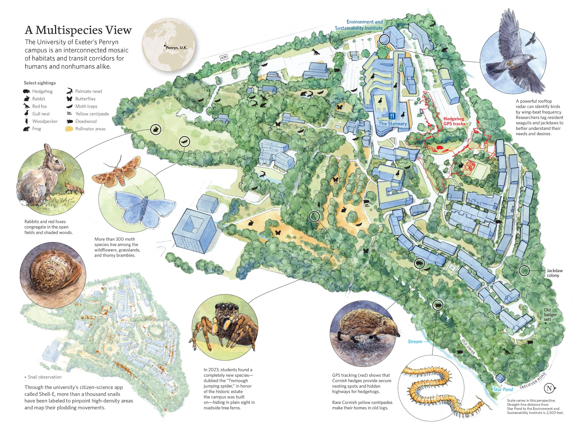 Illustration by Oliver Uberti.
Immediately, a vibrant new map unfolds, displaying not just the resident housing and sidewalks she recognizes, but also a galaxy of other color-coded markers. Seagull nests and flyways. Ponds teeming with frogs and newts. Hedgehog burrows and transit routes. A clickable kaleidoscope in the palm of her hand.
Locating the grassy quad she’s standing on, the student zooms in on her favorite dining hall, the Stannary. Identified on the map by a blue fork-and-knife icon as a popular eatery, she notices that it’s also tagged as a stopping point on the seagulls’ flight path. Slowly peering up at the brick building ahead of her, she glances to the roof. Her eyes bulge when she spots a long row of birds, who appear to be having lunch. To nobody in particular, she blurts out, “No. Way.”
Penryn may seem small to us…but to a snail, it’s a seemingly endless world to explore.
This is the kind of scenario that animal geographer Dr. Sarah Crowley envisioned when she began work on a first-of-its-kind multispecies map of the University of Exeter’s Penryn campus, in the far southwestern corner of the UK. Her map aims to achieve something as revolutionary as it is simple: reflect the housing, landmarks, and transit routes of all university residents, human and otherwise.
Touring the campus on an early-autumn morning with Crowley and the university’s biodiversity officer, Abhishek Dixit, I was struck by the earthy overgrowth of the school grounds, which nature appeared determined to reclaim. As we walked through a carpet of burnt-orange leaves, glistening with a fresh drizzle of sea mist—mizzle, in local parlance—Dixit noted that some corners of the campus are classified as temperate rainforests; and they sound the part. The perpetual buzz of mining bees mingled with the shuffle of rabbits through the bushes, woodpeckers’ rapid-fire drilling, and the hard-staccato tchack, tchack, tchack of ravenlike birds known as jackdaws, creating a subtle symphony.
At first glance, this quiet corner of the North Atlantic might seem an unlikely place to search for animal life. Nobody would confuse Penryn with the Amazon Basin or Serengeti as a wildlife hotspot, and at barely 100 acres, the campus is merely a satellite extension of a larger university system. But Penryn punches far above its weight in one notable regard: Nearly half of the university grounds are designated as green spaces, creating a landscape mosaic composed of thick forests, deep quarries, expansive grasslands, and dense marshes.
As we walked along a verdant path skirted by the compacted soil and stone of stately Cornish hedges, Dixit explained that identifying who is living on campus at any given moment has become something of a university pastime among the tight-knit populace of six thousand sustainability-oriented students. To date, more than 650 species have been found to call this place home—a figure we know because despite its wee size (or perhaps because of it), Penryn has become a living laboratory of animal monitoring.
For starters, it was the first institution in the world to boast a vertical-looking radar capable of identifying birds flying up to 4,000 feet overhead by analyzing the amplitude of their wingbeats. Every second, the radar can beam out 1,800 short-pulse radio waves in a massive cone shape. When the waves reflect back, the radar receives them and transmits data about the number, height, direction, and speed of aerial passersby.
At ground level, miniature GPS “backpacks” worn by hedgehogs provide ecologists with updates on the busiest thoroughfares used by Penryn’s spiniest denizens. (Predictably, they favor the hedges.) Motion-activated camera traps scattered around campus offer field reports on red foxes, badgers, and other nonhuman visitors, while the geography department’s high-resolution drone footage helps make sense of who or what is drawing animals to certain areas.
Their multispecies map is a…blueprint that enshrines the right to roam for the entire animal kingdom.
Eager to do their part, the university’s ecology society, or Eco-Soc, collaborates with other students to wage periodic “bio-blitzes,” crowdsourcing comprehensive distribution maps of moths and other invertebrate residents. During a 2023 blitz, students discovered a completely new species of jumping spider, and then promptly found thirty more individuals from the same species across campus. Around the time of my visit, the university also launched a new citizen-science app called Shell-E, which hundreds of students have used to log and identify the convoy paths of Penryn’s thousand-plus snails as they painstakingly crawl across campus.
“The dream is to have most of the snails on campus individually marked so that when anybody stumbles across a snail and wants to follow their progress or see where they came from, they could go to the digital map,” says Professor Dave Hodgson, the project overseer. Penryn may seem small to us, he notes, but to a snail, it’s a seemingly endless world to explore. Hodgson’s field research has revealed that snails have a homing instinct of up to 30 meters (about 100 feet). That may not seem like a lot until you consider that snails move at about one meter per hour, turning a journey across Penryn’s walled garden into a multiday expedition.
In some respects, Penryn is the ideal setting for such a radical experiment to take place. The town is situated in Cornwall, one of Europe’s six ancient Celtic nations—communities shaped by common descent, traditions, culture, or language. Surrounded on three sides by sheer cliffs, Cornwall’s protruding peninsula faces the full brunt of harsh ocean gales, which sweep through the narrow cobbled streets of its many ports. This exposure has helped forge a distinct cultural identity that prioritizes the integration of human infrastructure with elements of the wilderness. The notion that nature begins only where humans end is anathema to the Cornish spirit.
The asserted “right to roam,” which argues that land should be accessible to all rather than walled off into private parcels, looms large here, as it does across northern Europe. This mindset is perhaps best exemplified along the craggy Cornish coastline, where hundreds of miles of public trails have been thoughtfully preserved in a light-touch way. Eschewing fences and pavement in favor of natural footpaths lined with brambles and shrubs, these slender pathways provide epic sea views while leaving the ancestral homes of other animals intact.
To Crowley and Dixit, their multispecies map is a natural extension of this worldview by identifying places meaningful to Penryn’s nonhuman residents and visitors. A blueprint that enshrines the right to roam for the entire animal kingdom.
__________________________________
From The Hidden Nations of Animals: A Grand Tour of Earth’s Wild Civilizations by Ryan Huling, illustrated by Oliver Uberti. Copyright © 2026. Available from Avery, an imprint of Penguin Publishing Group, a division of Penguin Random House, LLC.
Ryan Huling
Ryan Huling is an explorer and sustainable food systems specialist based in Sierra Madre, California. He currently serves as a senior writer at the Good Food Institute Asia Pacific. His columns have appeared in Nature, Wired, USA Today, The Nikkei, and the South China Morning Post.